
HistoryLocated in midtown Phoenix, the Coronado neighborhood (often referred to as Greater Coronado) covers over 1-3/4 square miles (just under 1200 acres) and includes around 4,000 households. Three historic districts— Coronado, Country Club Park, and Brentwood—make up much of the neighborhood. The western side of Coronado was constructed largely between 1920 and 1930 and reflects the California Bungalow and Spanish Colonial Revival building styles; the northern side is predominantly ranch styles common of the 1940’s. Throughout the neighborhood you will find the occasional contemporary infill home. Much of our neighborhood falls within the Phoenix Historic Preservation zoning guidelines. Descriptions below for Coronado, Country Club Park, and Brentwood were excerpted from the March-April 2008 Dispatch article written by Donna Reiner, PhD. |
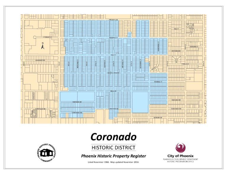
Coronado Historic District
Designated: January 1986The Coronado Historic District consists of a number of small subdivisions; many were originally portions of Syndicate Place, Homewood Tract, and Ranchitos Bonitos subdivisions. Construction of residences in the neighborhood generally went south to north, west to east. Most homes in the neighborhood are one-story. Typically the smaller subdivisions were not developer/architect driven, so homes were built over several years. Thus, one can find an interesting mix of architectural styles in Coronado, predominately bungalows (California, Classic, Craftsman), English Tudor, Spanish Colonial Revival, although one can also find examples of Pueblo Revival, Southwest (a blend of Spanish Colonial Revival and Pueblo Revival), and Transitional/Early Ranch. One exception is the Womack two-block subdivision on the eastern portion of the District that was constructed all at once. The Brill Line trolley ran along 10th Street from Washington Street up to Sheridan Street from 1913 to 1946. Emerson Elementary School, now the Phoenix Elementary School District Offices, opened in the fall of 1921. Our large neighborhood park, Coronado Park, was developed by the city in 1936 at Palm Lane and 12th Street. | Country Club Park Historic District
Designated: January 1993Country Club Park’s history begins in 1888 when Charles Orme filed a homestead patent that included this area. Orme sold it six months later to Thomas Pemberton, and it remained in his family until 1918 when a Du Pont family heiress, Ecutheria L. Du Pont, purchased it. She subsequently sold the 30 acres east of Dayton to the city for the North High School site in 1937. In 1939, the Aetna Investment Corporation (the original Country Club Park developers) purchased the parcel. A prime site for new building under FHA standards, the design contained curved, non-through streets, three-way intersections, and a 2 ½ acre park in the center. Half of the lots were developed prior to World War II, usually with simple Ranch style homes (the prototype for FHA construction). By early 1942, the subdivision construction slowed due to war-time building restrictions. The Eureka Investment Company took over the development of Country Club Park shortly after and hired the local architectural firm of Lescher and Mahoney, charging them to honor the FHA uniformity guidelines. By 1946, the subdivision was complete. | Brentwood Historic District
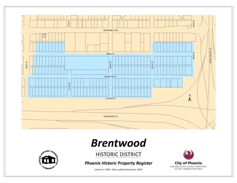
Designated: April 2003The Brentwood Historic District consists of several subdivisions platted between 1926 and 1946. It consists of single-family residences with only four exceptions: the Latter-Day Saints (Mormon) Stake Center at 1725 East Brill Street dating from 1947-1949 and three small apartment buildings. Although Ranch and Period Revival-style houses dominate the streetscape of the district, a few Southwest and Bungalow-style dwellings are also found. The oldest house in the district, 1821 East Willetta Street, was apparently constructed in 1916. This house and several other early 1920 buildings predate the platting of the various subdivisions that make up Brentwood. Governor George W. P. Hunt (Arizona’s first governor) resided at 1679 East McDowell Road until his death in 1934. His mansion was demolished in the 1950’s to make way for the commercialization of McDowell. |

Phoenix's Greater Coronado Neighborhoodby Coronado's own Donna J. Reiner, PhD and Jennifer Kitson
Paperback – February 27, 2012Although Phoenix may be the youngest major urban center in the United States, it was one of the first to recognize the significance of its historic neighborhoods by placing them in the city Historic Property Register. The three historic areas that form the basis of the Greater Coronado Neighborhood are Coronado, designated in 1986; Country Club Park, designated in 1993; and Brentwood, designated in 2003. The story of Phoenix is comprised of the collective experiences of many groups who have lived here. Weaving these multiple histories together through images of the people and places of the Greater Coronado Neighborhood, readers will have the opportunity to discover a neighborhood that is rich in resources and people who have helped Phoenix mature throughout the years. |
More Coronado History |
Do you know some historical facts about the neighborhood? If so, send us a message. We’d love to add to our website! |